
From The Hovenden Map of 1596 of parts of High Wycombe
High Wycombe, Buckinghamshire. Local History
There are copies at the County Record Office and at Wycombe Library Reference Room of a sketch map of properties in Bucks. belonging to All Soul's College in Oxford in 1596. Two properties are in Wycombe, the other two in Langley. They are photographic reductions of originals at the scale of 12 perches to the inch ( 1: 2376) reduced to 20 perches to the inch ( 1: 3960).
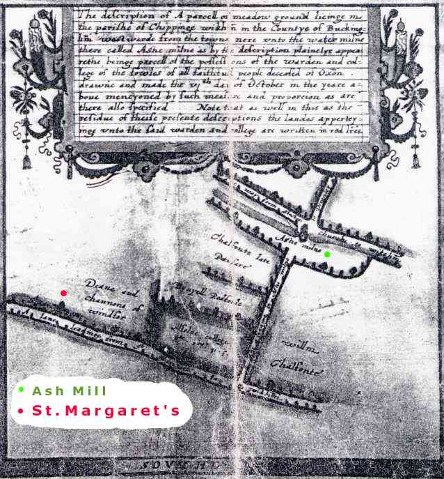
The Wycombe properties are described as being near Ash Mill and near Temple Mill, but the latter description appears to be incorrect. The descriptions of the two areas are given here with original spellings.
Ash Mill"The description of A parcell of meadow ground lieinge in the parishe of Chippinge wikham in the Countye of Buckingham westwarde from the towne nere unto the water milne there called Ashe milne is by the description plainelye appearethe beinge parcell of the possessions of the warden and college of the Soules of all faithfull people deceased of Oxon. drawne and made the vi th. day of October in the yeare above mentyoned by such measure and proportion as are there also specified. Note that as well in this as the residue of theise presente descriptions the landes apperteyinge unto the said warden and college are written in red letteres."Temple Mill
"The description of a parcell of meadowe-grounde called woode crofte
lieinge in the parishe of Chippinge wickham in the Countie of Buckingham
Eastwarde from the towne nere unto A water mylne there called Temple mylne
as by the description plainelye appeareth whiche meadow is parcell of the
possessions of the warden and college of the Soules of all faithfull people
deceased of Oxon. drawne and made the vi th. day of October in the xxxviii
th. yeare of the raigne of our most gratious Soueraigne ladye Elizabeth by
the grace of God of Englande Fraunce & Irelande Queene defender of the faithe
&tc and in the yeare of our lorde god MDLXXXXVI. Robte Hovenden doctor of
diuinitye then being warden accordinge to the measure of xvi foote 1/2 to the
perche and after the proporcion of xii perches to an inche by Tho. Langdon
Note the meadow aforesaide appeareth herein written with redd letters."
( The use of the Olde English "milne or mylne" for a mill is interesting. It comes from the Latin "molina", hence "moulin" in French.)
Ash Mill Property
Enlarged version in Acrobat PDF format. 280kb
The map shows 4 roads :-" The way from Stokenchurche to wickham" = Oxford Road and Old West Wycombe Road
"A lane leading from St. Margarettes to wikham" = Desborough Road
"A lane leading to Ashe milne" = Westbourne Street
"To Downley" = The old way to Downley cut off by the construction of the railway = Hobbs Lane.
The land belonging to the college of about 2.7 acres was the rectangle bounded by Desborough Rd., Westbourne St., Short St., and Richardson St. A similar area between Richardson St. and Baker St. was owned by Danyell Redforde. The area between Baker St. and the river (no western boundary shown) was owned by (Wm.) Chalfonte (late Petifare). The land to the west of the College land was owned by the Deane and channons of windsor. The land to the east of Westbourne St. belonged to willm. Chalfonte and as no eastern boundary is shown, probably extended as far as Munday's Mead.
A building is shown on All Souls' property on the north side of Desborough Road, and L.J.Ashford considers that this is the Leper Hospital of St.Margaret and St.Giles. This would explain why, on the map, Desborough Road is shown as "a lane from St.Margarettes to Wickham" and why, in the 17th century, it was known as St.Margaret's Lane.
Now St.Giles is the patron saint of lepers, and Mrs.Cauvain reports that on an excavation at the Desborough Road/Avenue crossroads, skeletons were found without fingers. This suggests that they were lepers and appears to confirm that this is the site of St.Margarets, not in the grounds of Wycombe Abbey, according to Parker, and as shown on early Ordnance Survey maps.
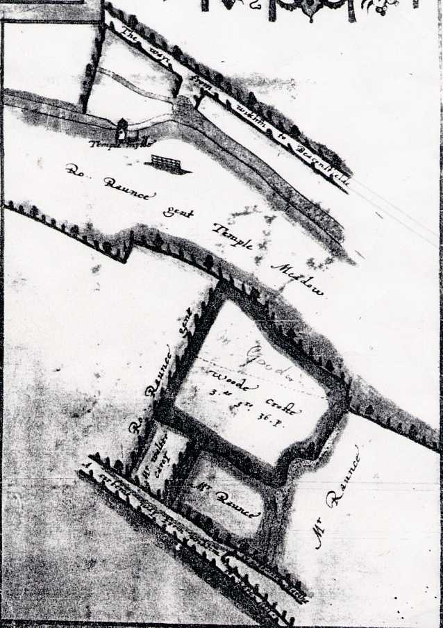
"Temple Mill" property
Enlarged version in Acrobat PDF format. 214kb
The land is described as being Eastwarde from the town. However, Temple Mill is about 250 yards west of the church so something is wrong. The map shows two parallel roads about 360 yards apart, and this is the exact distance between London Rd. and the old Windsor Rd.(now under the Dyke) at the east end of the Rye. The roads are called "The way from wikham to Beaconsfielde" and "A certain way from Wikham to wikham Marche,(with a branch "to Kepe Hill"). This tends to indicate that by 1596 Easton St. had been extended across the grounds of St. John's Hospital (by then the Grammar School) to form the main eastern exit from the town. A positive clue to the location of the College property is the semi-circular line at the east of the site. This is almost certainly the spring (a watercress bed in the 1930's) to the south of Rye Mill. This ties in with the point at which the Windsor road turned N.E. and where any track to Keep Hill would branch off.
The area of Wood Crofte is given as 3ac. 3r. &36p., which is slightly under 4 acres, and this is drawn exactly to scale.
The northern boundary corresponds with a track from Pann Mill as on the 1st. edition Ordnance Survey map. Also to scale is the old course of the Wye 40 yards south of London Rd. as it was before the canal leading to Rye Mill was constructed. However, Temple Mill is shown 350 yards from the spring, whereas it is actually about 1450 yds. Pann Mill is 460 yds. away, so it is not that, especially as the mill race as drawn is similar to that of Temple Mill. So the map is correct except for Temple Mill and Temple Mead.
Now apart from a small meadow belonging to Mr.Walter Carey, all other land was shown owned by Mr. Rance or Ro(bert?) Rance - probably the same person. John Rance was Mayor of Wycombe in 1552, lived at Bassetsbury Manor (east of Wood Crofte) and is said to have owned most of the original Manor of Wycombe. Temple Mead included a large area south of the Wye in the Newland area and it is possible that Rance's meadow covered most of the strip south of the River as far as Bassetsbury. In this case the "Temple" references on the map are given with a certain amount of artist's licence. The dog-leg is probably in Newland where West Field had a similar dog-leg possibly because the southern boundaries of St. Margaret's Lane (east) and Desborough Rd. were not collinear.
Wood Crofte (shown as Arable Piece on Parker's map), the two fields to the south of it (Pound Mead in Parker) and the meadow to the west of them must have been part of the Rye. Lorna Cassidy in "Discovering High Wycombe" says that John Rance came into conflict with the rights of the burgesses when he attempted to enclose some of the lands of Bassetsbury with hedges and ditches,and presumably these were part of the Rye. This map appears to show similar enclosures.
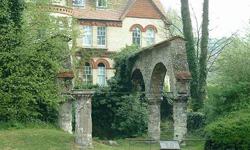
Remains of St.John's Hospital.
Further research is required
Related pages:
Strata Dusteburg
Old roads through High Wycombe.
High Wycombe Water Mills
in the Domesday Book.
K.A.Goodearl
Chorleywood
U.K.