 Lacey Green, Buckinghamshire.
Small Dean, Coombs and a Glimpse of the Promised Land
A two and a half mile circular walk.
© Dennis Claydon 1998-2012
Map
LGWalks Home Page
Car Park
Map
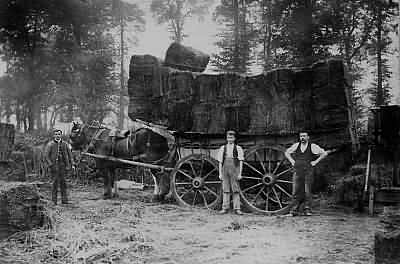
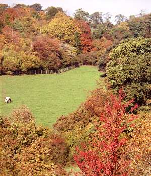 Small Dean Bank, adjacent to the carpark, is an area of permanent
grassland rich in flora and fauna, which is now in the care of the
National Trust.
Small Dean Bank, adjacent to the carpark, is an area of permanent
grassland rich in flora and fauna, which is now in the care of the
National Trust.
Small Dean Bank, adjacent to the carpark, is an area of permanent
grassland rich in flora and fauna, which is now in the care of the
National Trust.
There is a small carpark in Small Dean Lane. After leaving Lacey Green on the road towards Naphill, turn right at the first crossroads, before reaching RAF Air Command, and follow the narrow lane down to the bottom of the hill. The carpark is on the left.
Leave the carpark and turn right up Small Dean Lane for about a hundred yards. Then, on the left, go through a kissing gate, and into a field to join:
Footpath L1, Small Dean Lane to Church Lane, Lacey Green.
Water
Almost immediately after entering the field the path crosses an underground pipeline leading to Lacey Green Reservoir, which is next to New Road, by RAF Air Command. The pipes are 10ft in diameter. The Reservoir, constructed in 1986, holds 8 million gallons of water for domestic use in the High Wycombe area. The Reservoir is monitored from the control centre at Bourne End.
Almost immediately after entering the field the path crosses an underground pipeline leading to Lacey Green Reservoir, which is next to New Road, by RAF Air Command. The pipes are 10ft in diameter. The Reservoir, constructed in 1986, holds 8 million gallons of water for domestic use in the High Wycombe area. The Reservoir is monitored from the control centre at Bourne End.
The path goes straight ahead following the hedgerow on the right.
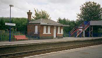
Saunderton Station and the Workhouse
The railway between High Wycombe and Thame was opened in 1862. Several years before, the Wycombe Poor Law Union erected a Workhouse at Saunderton. This building served 33 parishes, an area of 147 square miles and stood in 11 acres of garden on the present site of The Clair Foundation Charity Hub, by the main Risborough to Wycombe road.
In 1885 and 1889, the Guardians of the Workhouse requested that the Great Western Railway provide a Station for the delivery of supplies. On both occasions this request was refused as being 'uneconomical'. The building of a public institution 'five miles from anywhere', was, in the opinion of the GWR, a grave error of judgment on the part of the local authorities.
The dawning of a new century, however, saw the conversion to double track, and the construction of a Station at Saunderton. This, it was claimed, was not only to serve Saunderton, but the surrounding villages of Bledlow Ridge, Lacey Green, Loosley Row and Speen.
The Station is situated some two and a half miles from Lacey Green. Before the advent of bus services and with few cars in use, it was the main point of arrival and departure for travellers to the village. A horse and trap could be hired to transport passengers and luggage by road, but most villagers used this path on foot, making it one of the most important routes in the parish. Young children would walk the path daily, in all weathers and seasons, to catch the train to attend school in High Wycombe. Imagine the uproar at the mere suggestion of such a lonely journey today!
At least twice in its history the Station has attracted national headlines. Once for the part it played in apprehending two criminals, and also for a devastating fire.
To the left, in the main valley, is Saunderton Station.
Serious Crime
 It was the discovery of two first class season tickets, issued from
this Station in 1913, which enabled police to solve a mysterious
series of crimes. By chance, after widespread investigations by
Scotland Yard regarding a number of burglaries throughout London,
the Midlands and Southern England, two men were questioned at
Ashurst Station in Kent. The season tickets in their possession lead
to the recovery of a considerable value of stolen property, from their
hideaway cottage in Kiln Lane, Lacey Green. Most of the goods
had been conveyed to Lacey Green along this footpath. The two men,
posing as 'medical students', travelled up to London in the
evening and returned the following morning. It was said that the local
Police Constable would have received immediate promotion to sergeant
had he known two such wanted men were living on his doorstep!
It was the discovery of two first class season tickets, issued from
this Station in 1913, which enabled police to solve a mysterious
series of crimes. By chance, after widespread investigations by
Scotland Yard regarding a number of burglaries throughout London,
the Midlands and Southern England, two men were questioned at
Ashurst Station in Kent. The season tickets in their possession lead
to the recovery of a considerable value of stolen property, from their
hideaway cottage in Kiln Lane, Lacey Green. Most of the goods
had been conveyed to Lacey Green along this footpath. The two men,
posing as 'medical students', travelled up to London in the
evening and returned the following morning. It was said that the local
Police Constable would have received immediate promotion to sergeant
had he known two such wanted men were living on his doorstep!
Fire
The neighbourhood of Saunderton was aroused in the early hours of Monday 10th March 1913 by a disastrous fire at the Station. The vivid and dramatic accounts of the event record that the fire was 'roaring like a furnace'. Firemen from Princes Risborough and High Wycombe had great difficulty in obtaining enough water to fight the blaze. The contents of a nearby pond were used, together with water from the 1500 gallon tank at the Workhouse. When eventually the fire was extinguished only the blackened walls of the Station remained. It is curious to note that, despite the great heat, the clock, which hung on the wall in the centre of the Station, was still going, and showed the correct time.
As daylight dawned the climax of the drama unfolded. Two placards bearing the inscriptions, 'Votes for Women' and 'Burning to get the Vote', pointed to the authorship of the outrage. It was later proved militant Suffragettes were responsible for this act of arson.
Small Dean Farm and bank.
The Old Carriageway
Map
Here the path joins the remains of an old carriageway, leading to Grimsdyke House. This was probably constructed in the nineteenth century, to provide an easier access to the house from the south. A number of crabapple trees border the track here.
Grimsdyke House Map
This large residence, probably stands on the site of a far older building. Past owners of this house have tended to play the role of unofficial 'Squire' some acting as benefactors to the village. Such was the case at the latter end of the nineteenth century.
The Fatal Fete
Mr. John Forrest, the then owner of Grimsdyke, was also the President of the Lacey Green Cottage Garden Society. The first ever show of the Society was held in the grounds, at his invitation, on Monday 27th July 1891. The day dawned rather wet and gloomy. During the morning preparations were in progress in the large marquee which had been erected. The judging of fruits, flowers, vegetables, lace and beadwork was completed and prizes awarded. These were to be presented later in the day by Lady Buckinghamshire.
By early afternoon, when the show opened, the weather had brightened. The various side shows, including a beekeeping demonstration, were ready. Speen Band was in attendance, and a cricket match in progress. Around mid afternoon dark clouds began to gather and there was a shower, not heavy, but enough to stop the cricket match. The players and others took shelter under a large cherry tree.
Suddenly, without warning, there was a vivid flash of lightning, followed by a terrific clap of thunder and torrential rain. About twelve people where felled to the ground by the lightning. The whole event was thrown into utter confusion, women and children running about screaming and crying. Within minutes it was discovered that three men had been rendered unconscious and three more killed outright. After twenty minutes the heavy rain ceased.
As a mark of respect the whole event was abandoned. By a strange coincidence the victims were George Adams of Lacey Green, John Eggleton of Loosley Row and Henry Bowler of Speen. Thus, the whole community shared in the grief of this tragedy.
Edward Stone
The history of Grimsdyke House, however, goes back much further. This Estate was in the ownership of one family for two and a half centuries. By reason of careful husbandry and a series of wise marriages, the Stone family of Lacey Green had quietly prospered as yeomen during the seventeenth century.
The birth of a son, Edward, born to Edward and Elizabeth Stone on the 5th November 1702, no doubt occasioned much rejoicing. Edward's mother died while he was still an infant. His father remarried a daughter of John Grubb of Horsenden Manor, Lord of the Manor of Princes Risborough, a step up the social ladder. In 1716 Edward senior bought the manor of Owlswick, in the parish of Monks Risborough and thereafter styled himself "Gent". By this time the family was living in Princes Risborough.
Young Edward was intelligent, and in 1720 entered Wadham College, Oxford, graduating Master of Arts in 1727. He became ordained, serving a curacy at Saunderton. Returning to Wadham as a Fellow in 1730, he filled, in rotation, most of the College's posts. In 1738 he was appointed Rector of Horsenden, a Living which he retained for the rest of his life.
He married, resigned his Fellowship in 1741, and was inducted as Rector of Drayton, near Banbury. He built a house for himself overlooking Chipping Norton, where he lived with his son after the death of his wife in 1751. He became active in local affairs as a Justice of the Peace. He died in 1768 and at his own request was buried at Horsenden.
For many years Edward Stone suffered from intermittent fevers, for which he sought relief in herbal remedies. He believed that the remedy for his disorder would be found in proximity to its cause; if his fevers were induced by damp, then the cure would be found nearby. He experimented with the powdered dried bark of the willow tree and discovered that this produced dramatic results. In 1763 he wrote an account of his discovery which was later published. Although little notice was taken at the time, in fact, Edward Stone had stumbled upon salicylic acid the basis of our modern aspirin. We now recognise that the boy from Lacey Green had set up a major landmark in medical history.
A Blue Plaque commemorates his life in Chipping Norton Market Square.
Head for a second kissing gate beside a field gate straight ahead, and pass into a fenced track.
Follow the carriageway, which climbs gently, for approximately seventy-five yards to a field gate. Keep straight ahead, passing to the right of the gate, into a narrow fenced path. Still climbing, this leads to a small gate. Pass through the gate, cross a farm track and through a kissing gate opposite into a hedged path.
To the right can be seen the buildings of Grimsdyke Farm. Beyond, hidden from view by the trees, is Grimsdyke House.
Hambye Close
Map
 Hambye Close was so named to commemorate the twinning of Lacey
Green Parish with Hambye in France. The site on which these houses
stand has a checkered but interesting history.
Hambye Close was so named to commemorate the twinning of Lacey
Green Parish with Hambye in France. The site on which these houses
stand has a checkered but interesting history.
Life in Victorian days in Lacey Green was very hard and many villagers were poor. Most were employed in agriculture or as "chair bodgers", working in the surrounding beechwoods or in cottage workshops, serving the High Wycombe furniture industry. Their wives would supplement the meagre family income by making and selling Buckinghamshire pillow lace.
The Vicar and the Tennis Court
In 1898 a new Vicar arrived in the Parish, the Revd. William Robson with his wife, from Cheltenham. Both were keen tennis players. In 1900, on the site that is now Hambye Close, the Vicar ordered the erection of an indoor Tennis Court, measuring 118 feet by 20 feet, solely for the use of his wife and himself.
Although he owned property in Cheltenham, the Vicar must have been a very wealthy man to have contemplated such an extravagance. The building, of brick construction with skylights in the roof, was probably unique in its day. The "sprung" wooden floor being made to a very high standard by a local builder, constructed with narrow boards "secret nailed", painted green, and with a special non-slip surface. The Vicar and his wife enjoyed the use of the Court for some years. What the parishioners thought of it is not recorded.
The Vicar's story, however, is a very sad one. Due to an accident of some kind, first he lost his health and then his wife, who left him to return to Cheltenham. He lived alone in the rambling Vicarage. The Tennis Court fell into disrepair and apart from brief use by the Army during the First World War, was to remain silent until the Vicar's death in 1922.
 After the Revd. Robson's death the Tennis Court was bought by Mr.
Harold Carter, head of Carter's of Broad Street, Merchants and
Shippers, in the City of London. The Carters resided at Grimsdyke,
living in some style, employing many servants, gardeners and grooms.
After the Revd. Robson's death the Tennis Court was bought by Mr.
Harold Carter, head of Carter's of Broad Street, Merchants and
Shippers, in the City of London. The Carters resided at Grimsdyke,
living in some style, employing many servants, gardeners and grooms.
The derelict Tennis Court was lavishly restored, including ladies and gentlemen's washing and changing facilities. The Carters often held tennis parties, entertaining the current Wimbledon stars of the day, most of whom played on this Court.
However with the outbreak of the Second World War, Mr. Carter transferred his business here from London, and used the Tennis Court as offices and accommodation for his staff.
After the War the building was bought by a Canadian, Austin Hoy. He put the building to another unusual use, the manufacture of coal mining machinery. Coal Chains, used for cutting coal, were produced here and despatched to mines throughout Great Britain. There was also a good export trade to Canada, Ireland, France, India and Australia. After Austin Hoy moved to Saunderton the building was used as a Warehouse, firstly for a builders merchant and latterly by a sweet manufacturer. The building once again fell into disrepair for some years, until after almost a century of service, in 1991, it was demolished to make way for Hambye Close. Opposite Hambye Close is:
Hambye Close was so named to commemorate the twinning of Lacey
Green Parish with Hambye in France. The site on which these houses
stand has a checkered but interesting history.
Life in Victorian days in Lacey Green was very hard and many villagers were poor. Most were employed in agriculture or as "chair bodgers", working in the surrounding beechwoods or in cottage workshops, serving the High Wycombe furniture industry. Their wives would supplement the meagre family income by making and selling Buckinghamshire pillow lace.
The Vicar and the Tennis Court
In 1898 a new Vicar arrived in the Parish, the Revd. William Robson with his wife, from Cheltenham. Both were keen tennis players. In 1900, on the site that is now Hambye Close, the Vicar ordered the erection of an indoor Tennis Court, measuring 118 feet by 20 feet, solely for the use of his wife and himself.
Although he owned property in Cheltenham, the Vicar must have been a very wealthy man to have contemplated such an extravagance. The building, of brick construction with skylights in the roof, was probably unique in its day. The "sprung" wooden floor being made to a very high standard by a local builder, constructed with narrow boards "secret nailed", painted green, and with a special non-slip surface. The Vicar and his wife enjoyed the use of the Court for some years. What the parishioners thought of it is not recorded.
The Vicar's story, however, is a very sad one. Due to an accident of some kind, first he lost his health and then his wife, who left him to return to Cheltenham. He lived alone in the rambling Vicarage. The Tennis Court fell into disrepair and apart from brief use by the Army during the First World War, was to remain silent until the Vicar's death in 1922.
After the Revd. Robson's death the Tennis Court was bought by Mr.
Harold Carter, head of Carter's of Broad Street, Merchants and
Shippers, in the City of London. The Carters resided at Grimsdyke,
living in some style, employing many servants, gardeners and grooms.
The derelict Tennis Court was lavishly restored, including ladies and gentlemen's washing and changing facilities. The Carters often held tennis parties, entertaining the current Wimbledon stars of the day, most of whom played on this Court.
However with the outbreak of the Second World War, Mr. Carter transferred his business here from London, and used the Tennis Court as offices and accommodation for his staff.
After the War the building was bought by a Canadian, Austin Hoy. He put the building to another unusual use, the manufacture of coal mining machinery. Coal Chains, used for cutting coal, were produced here and despatched to mines throughout Great Britain. There was also a good export trade to Canada, Ireland, France, India and Australia. After Austin Hoy moved to Saunderton the building was used as a Warehouse, firstly for a builders merchant and latterly by a sweet manufacturer. The building once again fell into disrepair for some years, until after almost a century of service, in 1991, it was demolished to make way for Hambye Close. Opposite Hambye Close is:
Continue along the hedged path to emerge into Church Lane. Turn left and follow Church Lane until reaching Hambye Close on the right hand side.
Footpath L3, Church Lane, Lacey Green to Lower Road, Loosley Row.
Floyd's Farm
Map
These small fields are all that remain of Floyd's Farm, a typical Chiltern smallholding of the late nineteenth and the early twentieth century. Both cottage and barn, situated a little north of the footpath, are now converted into very desirable residences.
Several generations of Floyd's have farmed this land, keeping cows, pigs, chickens and Aylesbury Ducks. Peter and Ann Floyd were married about 1854. They honeymooned in the cottage and over the following seventy odd years were content never to leave the Farm. Peter not only farmed the original six acres, but was also a shoemaker. He took the shoes he produced to The Lee, near Wendover, where an agent dealt with his goods. In the 1920's, well into their nineties, they were both still active.
Ann, born in 1833 at Aston Clinton, came to Lacey Green as a domestic servant at the age of fourteen. For her generation, Ann was very privileged, she could read and write. The Vicar of the day was so impressed with her ability, that after three or four years, he invited her to become the first village governess. Ann, in her own words, taught the children "...their letters and a little summing" (writing and arithmetic). Mothers sent their children's clothes to school already "tacked", so that the pupils might be usefully employed by adding to their wardrobes. For these tasks Ann received the sum of half a crown a week from the Parish. In her younger days she would occasionally travel to London by stagecoach from High Wycombe.
Ann, even in her nineties, found great pleasure in reading at least two newspapers daily. She was always particularly delighted to hold a lively discussion with anyone on the political news of the times. Throughout their long lives together neither Ann or Peter ever saw the sea, nor did they wish to do so.
Cross the stile and head in a generally north-westerly direction towards a second stile on the far side of the field. Cross this into another small field.
Proceed in the same general direction to a third stile, and cross into a larger field.
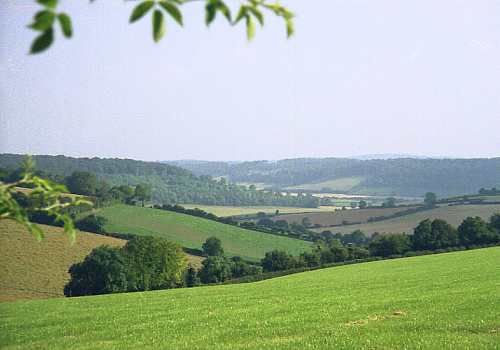
The Saunderton Valley towards High Wycombe
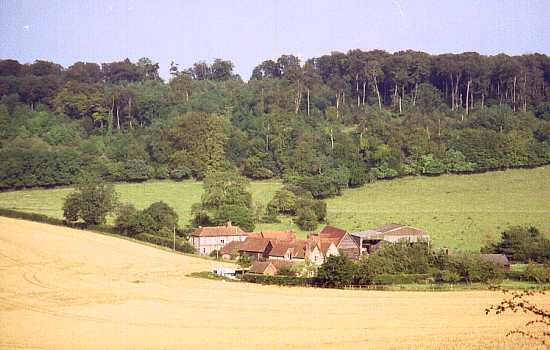
Promised Land Farm
Map
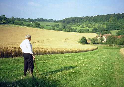
After wandering through the wilderness, like the Israelites of old, a glimpse of the Promised Land is a rewarding sight! In the secluded valley below, lies Promised Land Farm. Partly in keeping with the biblical Promised Land, "...a land flowing with milk and honey", a dairy herd existed until the end of the last century.
Westwards ever changing views open out above Promised Land Farm. The summit of Lodge Hill, together with Bledlow Ridge, can be seen above the intervening ridge. Beyond, acting as a landmark on the horizon, is the Post Office Tower at Stokenchurch.
Cross the corner of this large field, following the same north-westerly direction, to a fourth stile.
Over the stile and into another small meadow, make for a fifth stile situated in the north-western corner.
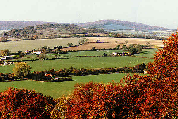
Lodge Hill with Bledlow Ridge beyond.
Lodge Hill
Views extend westwards across the Saunderton valley, over Lodge Hill, to Bledlow Ridge beyond. Rising from the valley floor, Lodge Hill guards the northern entrance to the Risborough Gap. Its isolated position, together with an air of remoteness, has caused it to become a favoured walking area, now crossed by the long distance Ridgeway Path. It is rich in flora and fauna.
Many indications still remain of its mysterious past. It has the remains of an Iron Age Settlement on its southern flanks and traces of two Bronze Age barrows on the its northern side.
In Victorian times the boys and girls of Loosley Row considered a walk to Lodge Hill as a great adventure. Some families made an annual trip on Good Fridays, armed with sticky hot cross buns and fizzy home made lemonade.
There is, of course, a legend of Lodge Hill. On the eastern side of the hill there was a dell, in which sycamore trees once grew. It was said that if one could run around the dell four times, whilst holding one's breath, the aroma of brimstone would arise. If a fifth circuit could be completed, then the Devil himself would appear. As far as is known no one ever managed to complete the circuits. However, this caused much excitement amongst the children.
The Risborough Gap
For early man, travelling north eastwards along the Icknield Way, following the escarpment above the spring line, this was the first break in the Chiltern Hills since the Thames crossing at Goring. Ancient man used the Risborough Gap and the Saunderton valley as a means of access into the Thames Valley. From the time of the late Saxon period onwards, this was the route used to transport salt from Droitwich (Hereford and Worcester) to the Sovereign's table in London. It is now used by both road and railway.
In the valley below is a cream coloured building, the "Rose and Crown"; at Saunderton. (See later.) The Parish of Saunderton is long and narrow, being six miles in length but not exceeding one mile in width.
The climb is rewarded, on reaching the summit. Panoramic views extend westwards across the Saunderton valley to Bledlow Ridge, and northwards across the Vale of Aylesbury. On a clear day the higher points of Brill and the Winchendon Ridge, to the west of Aylesbury, may be seen, with views extending towards Oxford.
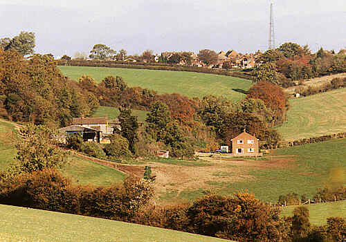
Promised Land Farm with Greenlands Mast on the Lacey Green Ridge beyond
Greenlands Mast
Map
To the north, on the horizon is the Greenlands Mast, belonging to Thames Water. It is a very important link in the control system for water supply and sewerage management in this area. The Control Centre situated at Bourne End, some twelve miles distant, operates 24 hours a day. It monitors, via a radio link with this mast, 42 unmanned pumping stations, a number of reservoirs, sewerage stations and treatment works.
As the path ascends widespread views unfold to the west and south. Westwards, over Lodge Hill, with Bledlow Ridge beyond. Southwards, the vistas extends from the beechwoods surrounding Bradenham, to a distant prospect of the Saunderton valley.
This section of the path is known locally as "The Grubbin", perhaps a corruption of "grubbing: to dig up". At the time of the Princes Risborough Enclosure in 1823 this ridge was heavily wooded. Since that time, however, work has taken place "grubbing up" the trees, creating the exposed landscape we now see.
Crossing the fifth stile, enter a hedged path running beside a bungalow, to emerge onto a metalled road. (This is Westlands Road, (Footpath L4) leading to the centre of Lacey Green.) Turn left here, into a hedged path, descending gently to a metalled track. (Footpath L8, Promised Land Farm drive.) Cross the metalled track and continue ahead by a fenced path running between hedges, alongside the boundary of a field. The path climbs steeply to gain the crest of the ridge.
The path then descends slightly, until the end of the field boundary is reached. Here, the path descends very steeply between two properties, "High Beech" and "Hillside", emerging into Lower Road, Loosley Row. Turn left in Lower Road and immediately right down a grassy bank to enter Footpath L5.
Footpath L5, Lower Road to Foundary Lane, Loosley Row.
This path, a link between Lower Road and Foundry Lane, is unique, being the shortest footpath in the Parish. Adjacent are two properties, "Randall's Cottage" and "Forge Cottage". These names reflect a little of the past history of Loosley Row. The Randall family were prominent in the eighteenth and nineteenth century as blacksmiths. "Forge Cottage" was formerly their workshop and "Randall's Cottage" their home.
On reaching Foundry Lane turn left and follow it to the junction of Lower Road with Little Lane. Cross the road into Footpath L6.
Footpath L6, Lower Road/Little Lane junction, Loosley Row to Coombs.
(continuing to Small Dean Lane.)
(continuing to Small Dean Lane.)
Gomme's Stile
Map
This stile can be claimed to be one of the most unusual in Buckinghamshire and is well worth a closer inspection. Constructed of iron, the stile has two steps, upon which is inscribed the following:
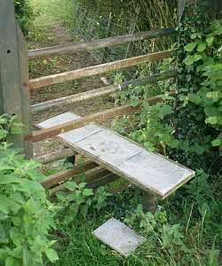
The step also bears the points of the compass.
Sadly, the Post Office closed in 1997, after serving the community for one hundred and forty four years.
This stile can be claimed to be one of the most unusual in Buckinghamshire and is well worth a closer inspection. Constructed of iron, the stile has two steps, upon which is inscribed the following:
"Footpath No. 6. Through the woods leads to Small Dean.
Down Little Lane to the Rose and Crown Inn.
The Whip Public House - along Lower Road and turn right at
the crossroads.
The Post Office is near The Whip - nearest telephone box
along Lower Road.
1784-1984 Gommes Forge, Showroom and Workshop - 230 paces
down Foundry Lane."
The step also bears the points of the compass.
Sadly, the Post Office closed in 1997, after serving the community for one hundred and forty four years.
Cross the stile onto a broad track following a fence on the left.
Gomme's Forge
This stile was made by Gommes Forge, they must therefore be allowed a little "engineering licence"! It is thought the Forge was in fact established in Foundry Lane in the early 1800's, not 1784, but all records have been lost in the mists of time.
It is certainly one of the earliest recorded industries in the area, in existence long before those of Princes Risborough. Around the middle of the nineteenth century, it is known John Gomme was in business, working as a Smith and Ironfounder. He was busy making and repairing farm machinery of many kinds, besides shoeing the horses that drew them. At one time the business employed no less than sixteen men, smiths, farriers, ironfounders, pattern makers, carpenters, wheelwrights and a millwright.
Unfortunately, John died at a comparatively early age, leaving a widow, Sarah, and three sons.
Sarah was a very remarkable woman, for she took control of the Forge and Foundry, working with her two eldest sons, and superintending the administrative side of the business. When Sarah died, in the early 1940's, she was 102 years of age.
Ralph Gomme, the youngest son, eventually took over the business. The pattern of farm work was changing, but the repair of farm machinery continued, including steam traction engines, in use before the introduction of the combine harvester. A new outlet was also being developed, the supply of woodworking machinery, such as planers and bandsaws, to the High Wycombe furniture industry.
Still managed by the same family, the bulk of the present work is ornate founding - casting, forging and working in wrought iron.
Coombs
Map
The area on the summit is known as Coombs, the site of a lost community. This path, leading up from the Lower Road/Little Lane junction once provided access to this settlement. During the eighteenth century it is known a farm stood here, and at the end of the nineteenth century there were four cottages. It is thought the name may derive from one, William atte Coumbe, who, in 1354, made a bequest of "one sheep" to the Church at Bradenham.
Here the path leaves the Parish of Lacey Green for that of Bradenham, but follows the boundary for most of the way to Small Dean Lane.
By a gentle incline the track continues, along the eastern boundary of the field, towards the tree crowned ridge ahead. An ever changing vista appears as the summit is approached.
This ridge is known as Callows Hill. The name is thought to derive
from the Anglo-Saxon, meaning "bald" hill.
Hangman's Oak
Hangman's Oak
Map
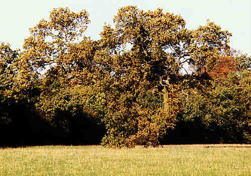
In the adjacent field to the left, standing in a small depression, is a lone oak tree. For several generations this tree as been known as "Hangman's Oak", traditionally the site of execution for convicted sheep thieves.
 On crossing the third stile, a second panorama opens out, this time to the
south. Westwards, to the right, is the continuing bulk of Bledlow
Ridge, with the intervening ridge terminating at West Wycombe Hill.
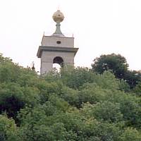
Here, the tower of St. Lawrence's Church, with its golden ball, is
just visible above the trees.
On crossing the third stile, a second panorama opens out, this time to the
south. Westwards, to the right, is the continuing bulk of Bledlow
Ridge, with the intervening ridge terminating at West Wycombe Hill.
Here, the tower of St. Lawrence's Church, with its golden ball, is
just visible above the trees.
On the horizon the prospect extends as far as High Wycombe. Closer to hand, to the east, are the beechwoods surrounding Bradenham. To the north-east is an unusual view of Lacey Green, with the Windmill and the Greenlands Mast as landmarks.
In the adjacent field to the left, standing in a small depression, is a lone oak tree. For several generations this tree as been known as "Hangman's Oak", traditionally the site of execution for convicted sheep thieves.
On crossing the third stile, a second panorama opens out, this time to the
south. Westwards, to the right, is the continuing bulk of Bledlow
Ridge, with the intervening ridge terminating at West Wycombe Hill.
Here, the tower of St. Lawrence's Church, with its golden ball, is
just visible above the trees.
On the horizon the prospect extends as far as High Wycombe. Closer to hand, to the east, are the beechwoods surrounding Bradenham. To the north-east is an unusual view of Lacey Green, with the Windmill and the Greenlands Mast as landmarks.
Continue ahead, crossing a stile, beside a narrow belt of woodland following the top of the ridge, with views on either side, to a second stile.
Cross the second stile, leaving the woodland, and with a tall hedge on the left, proceed to a third stile.
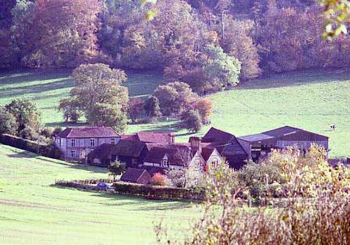
The path continues, following in a gentle curve the edge of the field, gradually descending towards the buildings of Small Dean Farm, in the valley below.

A steam excursion passing Bradenham
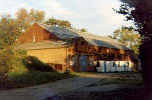
Small Dean Farm
Map
Small Dean Farm, lying in its own secluded valley, is surrounded by rolling arable farmland. Once forming part of the Bradenham Manor Estate, it is now in the ownership of the National Trust.
Squire Tempest
The original Farmhouse and buildings stand to the south of Small Dean Lane. The "new" Farmhouse, a handsome Victorian construction of brick and flint, stands to the north of the lane. This building was erected in the latter nineteenth century, by the then Squire of Bradenham, a Mr.Graves. On his marriage, Mr. Graves took the unusual step of taking his wife's family name of Tempest by deed-poll.
For many centuries Small Dean Lane marked the boundary between the Parishes of Princes Risborough and Bradenham. When it was pointed out to Squire Tempest that he was erecting his new Farmhouse outside his own Parish of Bradenham, he contemplated having it all pulled down, but the work had gone too far. No doubt Squire Tempest would have greatly approved of the move, over a century later, which placed the whole of Small Dean within Bradenham Parish.
Small Dean Farm
William Saunders
One of the first tenants of the new Farmhouse was William Saunders, son of another William, of Speen Farm. (Now the Home of Rest for Horses.) At an early age, whilst working for his Father, young William demonstrated his initiative by driving a team of horses to London with a wagon load of hay. This he quickly sold to the occupants of one of the large private houses which then stood in Piccadilly. The hay was of good quality, and at a fair price, so that he soon developed a lucrative trade with the London gentry.
On one such evening walk he was set upon by two footpads and robbed. As one can imagine he was not the type of person to be so easily relieved of his hard earned cash. He therefore devised a plan whereby he would not be robbed again! The garden of the Rose and Crown extended down to the railway track, so, as his train approached, he would open the carriage window and hurl his bag of golden sovereigns into the garden. On hearing the approaching train, his wife would quickly run down the garden to secure the money.
Before entering Small Dean Lane note the pudding stone on the left
of the path. These are to be found in various locations throughout
the Chilterns and are a geological feature dating from the Ice Age.
It is often thought early man used these stones as way markers.
Just short of the Farm the path turns at right angles into Small Dean Lane.
Small Dean Lane
For many centuries the eastern section of this lane marked the southern boundary of Princes Risborough Parish. Today, roughly the same section forms the boundary between the Parishes of Bradenham and Lacey Green.
For many centuries the eastern section of this lane marked the southern boundary of Princes Risborough Parish. Today, roughly the same section forms the boundary between the Parishes of Bradenham and Lacey Green.
From here it is but a short walk back to the carpark.
Other related pages on this website:
> The Speen Alps Another walk. Through the woods and fields around Speen.
> The Speen Alps Another walk. Through the woods and fields around Speen.
The Llamas the Windmill and the Wardrobes
A circular walk to the north of Lacey Green.
Lacey Green Village. Local history, the Windmill and other pages (This website's home page)
Many Photos of Buckinghamshire and Beyond